What's new

Taking Notes While Riding?

Thanks for your patience! Now I see your point. I didn’t follow your previous instructions. :fpalm

I just tried creating a route from scratch in BaseCamp it drew a straight line using the Global Map. I switched to the map I bought from VVmapping and it worked! Unfortunately I didn’t bring my GPS to work today so I can’t try it with it plugged in or try loading them.

Thanks again, this will be very helpful!
 
Why is garmen preferred over phone gps? I only use the phone in the truck. And have never used anything on the bike except memory or notes. Up until late 2019 I used maps in vehicles. Maybe I am missing back road routes. Ohio was easy to guess navigate with a grid like system. But in the south the same backroad rd can go east and west creating a circle. Is the gps unit really needed? I have recieved various answers on this topic and a Kyocera phone always seems to be mentioned.
 
Why is garmen preferred over phone gps? I only use the phone in the truck. And have never used anything on the bike except memory or notes. Up until late 2019 I used maps in vehicles. Maybe I am missing back road routes. Ohio was easy to guess navigate with a grid like system. But in the south the same backroad rd can go east and west creating a circle. Is the gps unit really needed? I have recieved various answers on this topic and a Kyocera phone always seems to be mentioned.
I guess it's really personal preference. For the ride that I've been talking about here it would have been impossible without accurate tracks. The signage sucked and there was a lot of spots that were very confusing even with GPS. Also, I don't want to use my phone for a variety of reasons. One is I don't want to break or lose it. It's my only means of communication in case of emergency. I also like the hand held GPS because it runs on AA batteries so I don't have to worry about running out of power or charging it. Also, in case of an emergency (bike's broken) I can use it to navigate my way out. Basically I trust the GPS more than my phone.

Navigational errors where one of my biggest frustrations on that trip. I was often tired and hungry and then realizing that I was off course and had to back track the same tough section I just came down was a kick in the nads. Don't misunderstand, I wanted a serious physical and mental challenge and that's exactly what I got! I learned a lot about myself on that ride and am very grateful for all the struggle and adversity.

Here's one of countless examples of me losing the trail. This was about 8 hours into day 4. The green line is the MCCCT track I programmed into the GPS that I got from the MI DNR. The red/white is where VVmapping's basemap was saying the MCCCT should be. I couldn't find any signs. The yellow/red diamond is the wrong trail as is the purple line. The blue line is my actual track as I looped back and forth trying to figure out why I couldn't find the trail.
!!Screenshot 2023-02-10 13.55.15 -Copy.png


I finally spotted a sign. Who would have thought it'd be on the other side of a ditch off the side of the trail? :lol2 
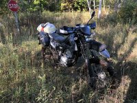
It doesn't look like much but it was a mud hole with a rut right down the middle.
!2022-10-04 16.32.09.jpg


Here's the view back to the trail I just came off of. You can see at the bottom how narrow the exit was. If I'd gone to the side at all I wouldn't have made it out and probably tipped over.
!2022-10-04 16.33.16.jpg


Swamp pudding! If I went down in that I think that would have doomed my trip.
!2022-10-04 16.33.45.jpg


Can I get a CSB?! :D

1106514-cool_story_bro_super.jpg
 

Attachments

  • !2022-10-04 16.33.35.jpg
    !2022-10-04 16.33.35.jpg
    6.2 MB · Views: 4
Wow on the terrain..I have 2 accounts of lost in the woods from friends. One was ohio on a cloudy day and the other in a southern swamp. Both times it took another person to get them out. Niether had used compass headings and land marks. Both had cell phones but became disoriented. The ohio friend had gps and grew up in the woods...but no way points. And add some health issues. The daughter of a friend in the swamp was at noon and he used the truck horn and talking to calm down the situation. Both of these could have gone bad. Down here is no place to get lost. I might get a unit to mess with the idea for navigation. I have played with compass and landmarks. Ha..I think I get it now!
 
Wow on the terrain..I have 2 accounts of lost in the woods from friends. One was ohio on a cloudy day and the other in a southern swamp. Both times it took another person to get them out. Niether had used compass headings and land marks. Both had cell phones but became disoriented. The ohio friend had gps and grew up in the woods...but no way points. And add some health issues. The daughter of a friend in the swamp was at noon and he used the truck horn and talking to calm down the situation. Both of these could have gone bad. Down here is no place to get lost. I might get a unit to mess with the idea for navigation. I have played with compass and landmarks. Ha..I think I get it now!
That’s scary stuff.

I’m far from an outdoorsman. I went to the UP with two friends (both experienced outdoors guys) a couple of years ago to help build a tiny cabin. We were way out in the middle of nowhere. That’s where I got the bug to challenge myself and do adventurous stuff. I bought my bike shortly after I returned.

Anyhow, when we were up there I hiked out maybe half a mile to do some target shooting. When walking back I was completely disoriented. I literally had a GPS in one hand and a compass in the other. Both were telling me to go one way but my gut was telling me to go the other. I did the wise thing and followed my nav aids and made it back but it was a real eye opener about how easy it’d be to get lost.
 
Whenever I do long trips off road, like the BDR, I'll usually type out a set of directions and my ICE info and tape it directly to the tank. Haven't used it for notes specifically but its nice to have, Also gives anybody finding my wreck a good idea of what I was doing and who to tell :lol3
8j-WAAX9xnBT_&_nc_ad=z-m&_nc_cid=0&_nc_ht=scontent.jpg
 
That’s scary stuff.

I’m far from an outdoorsman. I went to the UP with two friends (both experienced outdoors guys) a couple of years ago to help build a tiny cabin. We were way out in the middle of nowhere. That’s where I got the bug to challenge myself and do adventurous stuff. I bought my bike shortly after I returned.

Anyhow, when we were up there I hiked out maybe half a mile to do some target shooting. When walking back I was completely disoriented. I literally had a GPS in one hand and a compass in the other. Both were telling me to go one way but my gut was telling me to go the other. I did the wise thing and followed my nav aids and made it back but it was a real eye opener about how easy it’d be to get lost.
It still surprises me how easily something like that can happen, when getting my pilots license it really drove home how easy it was to "see" oneThing while your instruments tell you something else. On my offroad middle of no where trips I still generlaly trust my "instrument" like GPS but I've also learned to do that while verifying and not just blindly
 
I forgot also happeneded to my father when he was 6yrs old in Austria. He went into the woods picking mushrooms. He became very lost. I think he climbed a tree to spot the terrain. Of course panick set in. He ran in one direction. Been gone for hrs so the whole town started to search for him. They found him in a church in the next town. The 411 stories terrify me. Maybe taking notes is mental challenge and trying not to get lost is the motivation. All the accounts had a good ending. But have a creepy resemblance to 411 acounts. My ohio friend had walked in circles. And when he got back to the truck everything was the opposite direction of what he had thought. Also the gps was not functioning well but a cell phone and a friend got him out on landmarks. When he passed the same point he made the call.
 
Last edited:
Whenever I do long trips off road, like the BDR, I'll usually type out a set of directions and my ICE info and tape it directly to the tank. Haven't used it for notes specifically but its nice to have, Also gives anybody finding my wreck a good idea of what I was doing and who to tell :lol3
8j-WAAX9xnBT_&_nc_ad=z-m&_nc_cid=0&_nc_ht=scontent.jpg
That’s a great idea. I’m going to do that from now on. :thumb
 
It still surprises me how easily something like that can happen, when getting my pilots license it really drove home how easy it was to "see" oneThing while your instruments tell you something else. On my offroad middle of no where trips I still generlaly trust my "instrument" like GPS but I've also learned to do that while verifying and not just blindly
that’s interesting. On my trip last year I also took a compass as a backup in case of emergency. I also had my “first line” gear in my hydration pack so if for some reason I did have to abandon the bike I had some important gear already on me like the compass, a lightweight tarp, space blanket, extra batteries for the GPS, etc.
 
For the analog types Rite in the Rain (sp?) notebooks are good with waterproof paper that is quite durable. I carry a small one in my pocket along with a pen set.

Maybe I'll go back to keeping a bit of a travel diary when I go on my TT ride in August.

was cleaning up the MVI office today, and voilà !

1676156522537.png
 
Last edited:
We had those Magic Slate things when I was a kid, write, lift the clear cover and it erases...

Now they have a product called the Boogie Board (I think Jot is the parent company) that works similarly but erases electronically when you press the button. I keep one in the garage to prevent 5,000 post-it notes getting lost, this forces me to actually enter the info in the computer later or toss it because it wasn't really that important. Given the space I will hoard up receipts and notes which is why I switched to a small front pocket wallet.
 
I prefer to dictate notes to my phone while moving.
 
Still like the e paper idea with all data points. Everything from gps cordinates to 100 other points all screen shot from a button on the handle bar. Could even take photos at the same time. Other wise it is nice just to pull over and do it the old school method. Talking to a device... I guess could work but to look at tire temps, gps and whatever seems distracting to dictate then listen to later. Then create some form of spread sheet. I think I would dictate a scfi novel while riding before recording my data. Or just chat on ham or cb radio. Then pull off to take notes.
 
  • Like
Reactions: CTG
I'd dictate notes starting each with a waypoint reference. It isn't rocket science. :dunno

For me it is usually taking notes for work while I am doing something else.
 
Last edited:
Do you take the other data points? Like what egt was or altitude...when flying. I have an edr that is not mine but is accessible through law. There is a disclaimer..but I don't legally own the edr or have a backup. So cordanites are one thing but anything else....but I like the original post the most!... even if I can fathom 200 extra data points at a click of a button.
 
It sound like you are looking for full data logging solutions. That is not what I am talking about.
 
Top Bottom Back Refresh