Pdsmith505
Well-known member
Aztec, NM likes to claim to have as many arches as south-east Utah, so they list known arches on their website with GPX files to help find them: http://www.aztecnm.com/arches/index.html
But, a perusal of the descriptions for each arch shows that, while there are a handful of big ones, many of the listed spots only have a mouse-hole.
This is my attempt of seeing the bigger ones of the "Aztec" region in a single run. Turns out I should have started a couple hours earlier than I did!

After separating out the supplied .GPX files into "significant" and "minor" arches (and tossing the "miniature" listings), I went ahead and roughly plotted a path to hit all the "significant" ones. A big part of the initial planning was relying on Gaia's routing as "hiking" and avoiding backtracks as much as possible. The real world gave me a bunch of other options and inputs... single tracks, washes, locked gates, and alternates to pavement.

But, also, the real world had some real timelines. 120 miles and hiking to non-rideable (without breaking new trail on BLM land) arches put me at about 6h 30m, which ran me right up to sunset for this time of year. If I had left two hours earlier (instead of chatting over breakfast with family), I could have caught the last four significant arches in the region. There is also one arch firmly planted in private land behind a locked gate... I suspect it was recorded/reported by an oilfield worker who had access to the area as part of his job.
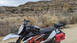
If I were to do it again... I'd allocate a full 8 hours to getting to all of them. I did end up running out of fuel on my KTM 690E and using my backup fuel near what is listed as Rattlesnake Canyon Wildlife Area (which I have never heard of, growing up in the region). Start and finish was off of US Highway 550 just north of Aztec... taking off down the Navajo Dam Road.
Anywho, on to the picutes!
But, a perusal of the descriptions for each arch shows that, while there are a handful of big ones, many of the listed spots only have a mouse-hole.
This is my attempt of seeing the bigger ones of the "Aztec" region in a single run. Turns out I should have started a couple hours earlier than I did!
After separating out the supplied .GPX files into "significant" and "minor" arches (and tossing the "miniature" listings), I went ahead and roughly plotted a path to hit all the "significant" ones. A big part of the initial planning was relying on Gaia's routing as "hiking" and avoiding backtracks as much as possible. The real world gave me a bunch of other options and inputs... single tracks, washes, locked gates, and alternates to pavement.
But, also, the real world had some real timelines. 120 miles and hiking to non-rideable (without breaking new trail on BLM land) arches put me at about 6h 30m, which ran me right up to sunset for this time of year. If I had left two hours earlier (instead of chatting over breakfast with family), I could have caught the last four significant arches in the region. There is also one arch firmly planted in private land behind a locked gate... I suspect it was recorded/reported by an oilfield worker who had access to the area as part of his job.
If I were to do it again... I'd allocate a full 8 hours to getting to all of them. I did end up running out of fuel on my KTM 690E and using my backup fuel near what is listed as Rattlesnake Canyon Wildlife Area (which I have never heard of, growing up in the region). Start and finish was off of US Highway 550 just north of Aztec... taking off down the Navajo Dam Road.
Anywho, on to the picutes!